


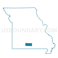
Bryan Voting District, Douglas County, Missouri
About
Outline

Summary
| Unique Area Identifier | 607742 |
| Name | Bryan Voting District |
| County | Douglas County |
| State | Missouri |
| Area (square miles) | 36.17 |
| Land Area (square miles) | 36.12 |
| Water Area (square miles) | 0.05 |
| % of Land Area | 99.85 |
| % of Water Area | 0.15 |
| Latitude of the Internal Point | 36.92508520 |
| Longtitude of the Internal Point | -92.25823740 |
Maps


Graphs
Select a template below for downloading or customizing gragh for Bryan Voting District, Douglas County, Missouri


Neighbors
Neighoring Voting District (by Name) Neighboring Voting District on the Map
- Brush Creek Voting District, Douglas County, MO
- Cass Voting District, Douglas County, MO
- Champion Voting District, Douglas County, MO
- Clinton Voting District, Douglas County, MO
- Jackson Voting District, Douglas County, MO
- McKinley Voting District, Douglas County, MO
- Richland Voting District, Douglas County, MO
- Wood Voting District, Douglas County, MO
Top 10 Neighboring County Subdivision (by Population) Neighboring County Subdivision on the Map
- Brush Creek township, Douglas County, MO (397)
- Wood township, Douglas County, MO (366)
- Cass township, Douglas County, MO (365)
- Bryan township, Douglas County, MO (346)
- Richland township, Douglas County, MO (304)
- Champion township, Douglas County, MO (269)
- Clinton township, Douglas County, MO (249)
- Jackson township, Douglas County, MO (239)
- McKinley township, Douglas County, MO (204)
Top 10 Neighboring Unified School District (by Population) Neighboring Unified School District on the Map
- Mountain Grove R-III School District, MO (9,530)
- Willow Springs R-IV School District, MO (7,728)
- Cabool School District, MO (5,620)
- Dora R-III School District, MO (1,843)